Kim Eslinger
Editor
612-321-8040
kim@millcitymedia.org

Brianna Ojard
Associate Editor

David Tinjum
Publisher
612-321-8020
dave@millcitymedia.org

Claudia Kittock
Columnist / Non-Profits
Email Claudia...

Becky Fillinger
Small Business Reporter
Producer / Milling About
Email Becky...

Michael Rainville Jr.
History Columnist
Email Michael...

Doug Verdier
River Matters

Mill City Times is a not-for-profit community service. We do not sell advertising on this site.

Community Partners

Thanks to our community partners, whose support makes Mill City Times possible:

MILL CITY FARMERS MARKET

With over 100 local farmers, food makers and artists, MCFM strives to build a local, sustainable and organic food economy in a vibrant, educational marketplace.

Visit their website...

HENNEPIN HISTORY MUSEUM

Hennepin History Museum is your history, your museum. We preserve and share the diverse stories of Hennepin County, MN. Come visit!

Visit their website...

MEET MINNEAPOLIS

Maximizing the visitor experience of Minneapolis for the economic benefit of our community, making Minneapolis the destination of choice among travelers.

Visit their website...

MSP FILM SOCIETY

Promoting the art of film as a medium that fosters cross-cultural understanding, education, entertainment, and exploration.

Visit their website...

GREAT RIVER COALITION

Enhancing the Minneapolis riverfront environment—for people and pollinators.

Visit their website...

Cultural Cornerstones
Search Mill City
Recent News
Front Page Archives

Minneapolis Riverfront News

Covering life, work, and play in the Historic Mill District and Downtown Minneapolis Riverfront neighborhoods. Have an opinion, local news or events to share?  Contact us.

Entries by Michael Rainville Jr (91)

Friday
Jun042021

The Oldest House in the City

Article by Michael Rainville, Jr.

When the first wave of settlers came to the St. Anthony Falls area, they had the always challenging task of establishing a successful city. In 1849, the village of St. Anthony was made official, and with that, more people flocked to the area. One of the more prominent citizens who helped make St. Anthony a desirable place to live was Ard Godfrey. Doing all that he could for the area and its businesses, the mark he left on the city can still be seen in Chute Square where his house, the oldest in the city, stands today.

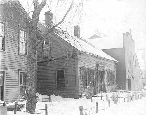
The house in its current location, with the Industrial Exopsition Building in the background from 1936.

A modern picture from the same vantage point.

When Godfrey and his family first arrived in St. Anthony in April of 1849, they did not have to wait long to move into their new house, which was funded by his colleague, Franklin Steele. With one-and-a-half stories of living space and a one-story kitchen extension, the Godfrey’s lived in a modest Greek Revival styled house. It features a wooden shingled gabled roof and two redbrick chimneys, and it served the family for roughly four years. While they did not dwell very long at this house, the time period was vital for the city as it saw Ard Godfrey rise to prominence. Shortly after moving in, he became the first millwright in the area when he built the first dam and saw mill on the east side of the waterfall. He was also the first Postmaster of St. Anthony, and chairman of the Ramsey County Commissioners Board, as Hennepin County did not include the east side until Minneapolis absorbed St. Anthony in 1872.

The decades following the Godfrey’s departure from the house saw it fall into disrepair. However, their descendants and other local groups saw the importance of the house and did what they could to save it. In 1905, the Hennepin County Territorial Pioneer's Association purchased the house with intentions of preserving it, however, they could not raise the funds need to do a proper restoration. This effort caught the attention of the Minneapolis Park Board, and in 1909, they purchased the land that is now Chute Square on Central and University in order to move the house there, restore it, and open it as the City’s first house museum. From the time the Godfreys moved out to the present day, the house itself has moved four times. Its original location was Prince Street and 2nd Avenue SE, then moved to 2nd Avenue SE and Central, 109 Prince Street, Ortman Street and Bank Street, and finally, to its current location in Chute Square. It was closed to the public in 1943, and stayed that way until the late 70’s when the Woman’s Club of Minneapolis completed the last major restoration of the house.

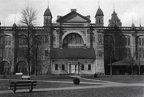
The house as it once stood at 109 Prince Street.

As one of the few remaining original structures from the early days of Minneapolis, the Ard Godfrey House serves as a reminder of a time when our beloved city of almost half a million people consisted of only a few thousand. With East Hennepin growing by the day, it’s hard to imagine what the area was like in 1849 when Ard Godfrey first came to the city, but there’s no questioning that he and his family would be proud of the growth the neighborhood and city has seen since their time. It may not standout among the more modern tall buildings and condominiums, but the quaint little Ard Godfrey House is here to stay. 

- - - - - - - - - - - - - - - - - - - - - - - - - - - - - - - - - - - - - -   

About Michael Rainville, Jr.

A 6th generation Minneapolitan, Michael Rainville Jr. received his B.A. in History from the University of St. Thomas, and is currently enrolled in their M.A. in Art History and Certificate in Museum Studies programs.

Michael is also a lead guide at Mobile Entertainment LLC, giving Segway tours of the Minneapolis riverfront for 5+ years.

He can be reached at mrainvillejr@comcast.net.

Wednesday
Jun022021

The Pioneers and Soldiers Memorial Cemetery

Article by Michael Rainville, Jr.

At the corner of Cedar Avenue and Lake Street in South Minneapolis lies the oldest surviving cemetery in the city. Housing roughly 20,000 graves, the Pioneer and Soldiers Memorial Cemetery served the early settlers of Minneapolis from when it first opened in 1853 to its closing in 1919. Since then, it has turned into a peaceful area to honor those who paved the way for residents of this city and state.

1936 photo of the front gates of the cemetery

The founder of the cemetery, Martin Layman, settled in South Minneapolis with his wife Elizabeth in early 1853, where they built the 6th house ever constructed on the west bank of the Mississippi. One of the major problems for early Minneapolitans was finding a place to bury their loved ones. Those who had connections with Fort Snelling could be buried there, but that was only a fraction of the population, and unlike east coast cities, churches did not have cemeteries on their grounds. To ease the situation, Layman decided to use his South Minneapolis land as a cemetery, and shortly after, on September 11th, 1853, his pastor’s 10 month old daughter passed away and became the first burial in the cemetery. Close to the city center and located on a major road that connected Minneapolis to Fort Snelling, Layman’s Cemetery quickly became a popular spot to bury loved ones, and in 1858, Layman started selling plots as demand was rising. Throughout the next few decades, the cemetery expanded a few acres at a time, and in 1886, the cemetery reached the extent it does today.

Dedication of the Philander Prescott monument at his gravesite in 1936.

The cemetery saw many veterans buried there who served in the War of 1812, the Civil War, and the Spanish-American War, as well as the first non-Native American child born in Minneapolis, the daughter of Colonel John H. Stevens. The cemetery is also home to three noteworthy early residents of the city. The first is Philander Prescott, who died in 1862. He was an important interpreter for the territorial and state government of Minnesota, as well as a successful businessman who had a trading post along the St. Croix River, where modern day Prescott, Wisconsin is located. The second noteworthy early resident of the city is Charles W. Christmas. One of the first surveyors of Hennepin County, Christmas played a significant role in establishing the borders of many towns and roads, and most importantly, much of Minneapolis’ original border. The final noteworthy resident has a much darker story. Known as “The Minneapolis Svengali,” and “the most bloodthirsty soul ever to usurp the human frame,” Harry T. Hayward is America’s first serial killer. Having lost thousands of dollars to a gambling problem and committing numerous arsons, the straw that broke the camel’s back was the murder of Katherine Ging near Lake Calhoun (recently renamed Bde Maka Ska). On March 11th, 1895, Hayward was found guilty of first degree murder and sentenced to death by hanging.

As of August 1, 1919, new burials were not allowed in the cemetery, and it took about a decade of planning to convince the city of Minneapolis to save the cemetery. Families of those interred in the cemetery received help from the Grand Army of the Republic, the Daughters of the American Revolution, and the American Legion to make sure the importance of the cemetery was not forgotten. In May of 1927, the Minneapolis City Council voted to issue $50,000 in bonds to purchase Layman’s Cemetery and implement improvements. Shortly after, Layman’s Cemetery was renamed Pioneer and Soldiers Memorial Cemetery, and during the next couple decades, monuments were erected, such as the memorial to the Pioneer Mothers and the Charles W. Christmas monument.

The Pioneer Mothers memorial

While it may just look like another small cemetery in the city, it is much more. From tragic deaths of children to the hanging of America’s first serial killer, the Pioneers and Soldiers Memorial Cemetery has 20,000 stories to tell. The next time you’re catching the light rail at the Lake Street-Midtown station or waiting for the bus at Cedar and Lake, would like to honor those veterens who fought in our first wars as a nation during this Memorial Day weekend, or just need to get out of the house in this 90-degree weather - take a few minutes to stroll through the tranquil and serene 165 year old cemetery to take in and treasure the monuments of those who lived here before us.

- - - - - - - - - - - - - - - - - - - - - - - - - - - - - - - - - - - - - -  

About Michael Rainville, Jr.

A 6th generation Minneapolitan, Michael Rainville Jr. received his B.A. in History from the University of St. Thomas, and is currently enrolled in their M.A. in Art History and Certificate in Museum Studies programs.

Michael is also a lead guide at Mobile Entertainment LLC, giving Segway tours of the Minneapolis riverfront for 5+ years.

He can be reached at mrainvillejr@comcast.net.

Friday
May212021

The Journey of the Merriam Street Bridge

Article by Michael Rainville, Jr.

As one can imagine, bridges are very important for cities along rivers, and Minneapolis is no exception. We have bridges for trains, pedestrians, and vehicles. They are a must, especially if you live on an island. From 1855 to 1987, the only bridge vehicles and pedestrians could cross to get to Nicollet Island was the Hennepin Avenue Bridge, but in the Spring of 1987, that changed.

Old Broadway Bridge 

In 1887, the second iteration of the Broadway Avenue Bridge was completed, and it lasted roughly 100 years. As the city grew, so did the need for larger bridges, so in 1985, they tore it down to make way for a the new, and current bridge. However, not all of it was lost forever. County officials, including the cousin of yours truly, John Derus, thought it would be a great idea to somehow save one of the spans of the old Broadway Bridge and move it down river to connect the lower east side of Nicollet Island to St. Anthony Main, and in September of 1986, they did just that. Picking out the best-looking span of the old bridge, they lowered it onto two barges to be floated down the river. Of course, a grand moment like this needed to be celebrated, so officials from the county and city had an event to send off the old truss. As Kate Parry of the Star Tribune said, “Sam Sivanich, chairman of the Hennepin County Board, leaned over to christen the fragment of the old Broadway Bridge [and] cracked a $2.89 bottle of pink champagne against the barge.” This was an expense that I’m sure all the taxpayers could get behind.

During the short journey to the back channel of Nicollet Island, a huge rainstorm passed over central Minnesota, and it wasn’t until the old truss was under the Burlington Northern Santa Fe bridge, now a pedestrian only bridge that connects Nicollet and Boom islands, when the Mississippi River started to rise. Well, the old truss got stuck, and the river kept rising! In order to make sure their bridge was not destroyed, BNSF parked five locomotives on the bridge just to weigh it down until the river level lowered and the old truss could continue its journey to its new home.

Merriam Street Bridge Minneapolis

This plaque can be found on the Merriam Street Bridge

Finally, on a Thursday in July of 1987, the Merriam Street Bridge opened. Joe Kimball, also from the Star Tribune, noted that the first vehicle across the “new” bridge was a horse-drawn carriage. Not only did this make the island more accessible, it opened up that part of the riverfront for further park development. Spanning roughly 256 feet, the Merriam Street Bridge seems like it was built for that part of the river. Oddly enough, the makers of the bridge were the King Iron Bridge Company, who also constructed the old 10th Avenue Bridge, and a plaque from its time as a span of the old Broadway Avenue Bridge is still present that lists the year, the company, and city engineer.

Bridges are important, our city’s history is important, and in 1986-87, an important decision was made to save both. Next time you cross the Merriam Street Bridge, take your time to look at it and appreciate it’s 19th century American architecture that helped settlers move West. It’s not just a fancy truss bridge. It’s history.

-  -  -  -  -  -  -  -  -  -  -  -  -  -  -  -  -  -  -  -  -  -  -  -  -  -  

About Michael Rainville, Jr.

A 6th generation Minneapolitan, Michael Rainville, Jr. received his B.A. in History, Graduate Certificate in Museum Studies, and M.A. in Art History from the University of St. Thomas. Click here for an interactive map of Michael's past articles.

Saturday
May012021

The Pier in the River

Article by Michael Rainville, Jr.

Mill City Times photo from 2014, taken shortly after a number of blocks fell into the river.Many people who enjoy the Minneapolis riverfront throughout the seasons have more than likely noticed an old stone pier jutting out of the river, but what’s the story behind it? Every year, more bricks seem to fall into the river, and it is only a matter of time before the Mighty Mississippi erases all memory of this mysterious pier.

Going back to the early years of Minneapolis, in 1855 when the Hennepin Avenue Bridge became the first permanent crossing to go over the entire Mississippi, the needs of the city were met. However, the city was quickly growing, and when Minneapolis unified with St. Anthony, it became clear that more river crossings were necessary. One of the new bridges that was to be built would become the 10th Avenue Bridge. It connected 6th Avenue SE to 10th Avenue S. Since there is currently a 10th Avenue Bridge just downstream, I will be calling this bridge the Old 10th Avenue Bridge for the sake of this article.

The Old 10th Avenue Bridge from 1906

A painting of a similar view by Arnold Ness Klagstad from 1937

In 1874, the short-lived Kansas branch of the King Bridge Company completed the Old 10th Avenue Bridge. It consisted of a two lane 1,100-foot-long iron deck truss on top of five stone piers, and served pedestrians, carts and wagons for about sixteen years. In 1890, the Twin City Rapid Company installed a street car line on the bridge, which just happened to be a stone’s throw away from the spot where their new steam power plant would be built only thirteen years later. Since it was an iron bridge and not a much stronger and sturdier steel bridge, it did not exactly provide the safest experience when crossing the river. Once automobiles found their way to the area, they were also allowed to cross the bridge, and only a couple decades later, in 1934, the bridge was closed for good.

World War II saw a great need for raw materials, so the unused bridge ended up being torn down for scrap in 1943. During its almost seventy-year existence, the Old 10th Avenue Bridge was a daunting sight that connected the east side of the Minneapolis riverfront to the west side. While it might not have been the safest bridge, it saw Minneapolis grow from carts and wagons to street cars and automobiles. It served as an important river crossing for the city and eventually contributed to the U.S.’s war effort. Nowadays, it’s hard to picture the bridge in its heyday, but the lone stone pier in the river acts as a gateway into its once boisterous life. Let’s just hope we can all cherish the pier while it lasts.

- - - - - - - - - - - - - - - - - - - - - - - - - - - - - - - - - - - - - - - 

About Michael Rainville, Jr.

A 6th generation Minneapolitan, Michael Rainville Jr. received his B.A. in History from the University of St. Thomas, and is currently enrolled in their M.A. in Art History and Certificate in Museum Studies programs.

Michael is also a lead guide at Mobile Entertainment LLC, giving Segway tours of the Minneapolis riverfront for 5+ years.

He can be reached at mrainvillejr@comcast.net.

Friday
Apr302021

The Meeker Island Lock & Dam

Article by Michael Rainville, Jr.

On the Mississippi River, where Minneapolis and St. Paul meet, an abandoned structure lies just beneath the waves. Between the shore and the navigation channel are the remains of the Meeker Island Lock and Dam, originally named Lock and Dam No. 2. While it was not operational for a very long time, the impact it had on the utilization of the river from St. Paul to Minneapolis is tremendous.

Screenshot from Google Maps showing the remnants of the lock.

During the mid-1800’s, paddle boats started to make the trek up the river and line the shores of St. Paul, bringing resources and people looking for a new home. While it was possible for boats to reach Minneapolis, it was a very dangerous trip. The eight-mile stretch from St. Anthony Falls to where the Minnesota River flows into the Mississippi was dotted with small islands and rapids with an elevation change of 110 feet. To take advantage of the power St. Anthony Falls was generating for the lumber and flour milling industries, Minneapolis needed to be connected to the transportation network that the river created. In 1898, after roughly fifty years of negotiations, the construction of two lock and dams, one near the Ford Bridge for St. Paul to harness electricity with, and the other near the Lake St. Bridge for Minneapolis, commenced. This would raise the level of the river and hide all those islands and boulders that made navigation very risky.

The Meeker Island Lock and Dam was the first to be built, and it was completed in 1907. On May 19th of that year, the Itura became the first boat to pass through the new lock, and the Meeker Island Lock and Dam became the first lock and dam on the entire Mississippi. During its short lifespan, the lock and dam would see anywhere from 200,000 to 475,000 tons of lumber a year pass through, which was the main use of the lock. The only other industry to use the lock was tourism and transportation. During the early years of the lock, the Army Corps of Engineers annual reports estimated that $15,000 worth of excursion business passed through the lock per year.

Photo of its construction, looking down stream with the Lake St. Bridge in the backgroud.

Photo of its construction, looking up stream.

Shortly after the Meeker Island Lock and Dam was completed, construction for the second dam, just downstream, began. Halfway through its construction, hydropower technology progressed so much that these two lock and dams would not be able to handle the new technology that was required for hydropower. Because of this, a new plan was agreed upon. In 1912, just five years since the Itura passed through its doors, the Meeker Island Lock and Dam shut down and was partially dismantled to make way for the new Lock and Dam No. 1. Not only would this new and larger lock and dam raise the river level even more in the river gorge, it would provide an immense amount of electricity. A man by the name of Henry Ford quickly realized this would be a perfect opportunity to open a new automobile factory and approached the city of St. Paul to strike a deal. I think we all know what happened after that.

Post card of the completed lock and dam.

While the Meeker Island Lock and Dam was only in operation for five years, it opened the river for safe travel up to Minneapolis, and laid the ground work for the current iteration of Lock and Dam No. 1, also known as the Ford Dam. The milling industries in Minneapolis were going to grow no matter what, but if it wasn’t for the idea that first popped up before the Civil War to install a series of locks and dams between the Twin Cities, it’s hard to believe that Minneapolis would eventually become the Mill City.

- - - - - - - - - - - - - - - - - - - - - - - - - - - - - - - - - - - - - - - 

About Michael Rainville, Jr.

A 6th generation Minneapolitan, Michael Rainville Jr. received his B.A. in History from the University of St. Thomas, and is currently enrolled in their M.A. in Art History and Certificate in Museum Studies programs.

Michael is also a lead guide at Mobile Entertainment LLC, giving Segway tours of the Minneapolis riverfront for 5+ years.

He can be reached at mrainvillejr@comcast.net.

Saturday
Apr172021

The Twin City Rapid Transit Company Steam Power Plant

Article by Michael Rainville, Jr.

While wandering across the Stone Arch Bridge and enjoying the downstream view of the Mississippi River gorge, it is hard to miss the four smoke stacks rising from a red brick building on the east bank. The Twin City Rapid Transit Company Steam Power Plant, now known as the Southeast Steam Plant, has played a very important role in the growth of Minneapolis. The original owners of the plant, the Twin City Rapid Transit Company, decided to construct the building in 1903 near the old 6th Avenue Bridge to provide electricity for their rapidly growing company.

The power plant circa 1906Back tracking a few decades, in 1875, Thomas Lowry bought the failing Minneapolis Street Railway Company and began to finance a project to lay rail on both sides of the river. These tracks would provide public transportation for thousands of Minneapolis residents. Lowry soon bought the St. Paul Street Railway Company and merged the two to make the Twin City Rapid Transit Company. In 1892, the company successfully transitioned from horse powered rail cars to electric powered, and soon averaged 5.5 million riders per year. The high demand created a big problem for their few steam power stations throughout the cities, so Lowry and his New York investors made the decision to build a power station on the east bank of the river, just beneath St. Anthony Falls.

The power plant, which was designed by the Chicago firm of Sargent and Lundy, began construction in December of 1902, and was up and running one year later in December of 1903. While its sandstone bedrock foundations and limestone and red brick walls are a common sight throughout the city, the Second Renaissance Revival style of the building was not. It may not be as ornate as Carnegie Hall or the Dresden Opera House, but it is still an example of remarkable local architecture. On the other side of its imposing façade, generators and boilers ran day and night to power an extensive streetcar system that rivaled San Francisco’s. When Minneapolis converted to buses in the early 1950’s, the Twin City Rapid Transit Company sold the power plant to Xcel Energy, then known as Northern States Power Company, and in 1976, its current owners, the University of Minnesota bought the plant to help power their Twin Cities campus.

The importance of the Twin City Rapid Transit Company Steam Power Plant was recognized on October 18, 1994 when the National Park Service added the building to the National Register of Historic Places. Within a half mile stretch of the Minneapolis riverfront that includes St. Anthony Falls, the Guthrie Theater, and the 35W Bridge, the Twin City Rapid Transit Company Steam Power Plant often gets overlooked. When you visit the University of Minnesota or see old streetcar tracks at the bottom of potholes that seem to pop up every Spring, you’ll be reminded of a cornerstone that helped connect the entire Twin Cities and contributed to Minneapolis’ growth.

- - - - - - - - - - - - - - - - - - - - - - - - - - - - - - - - - - - - - - - 

About Michael Rainville, Jr.

A 6th generation Minneapolitan, Michael Rainville Jr. received his B.A. in History from the University of St. Thomas, and is currently enrolled in their M.A. in Art History and Certificate in Museum Studies programs.

Michael is also a lead guide at Mobile Entertainment LLC, giving Segway tours of the Minneapolis riverfront for 5+ years.

He can be reached at mrainvillejr@comcast.net.

Monday
Apr122021

The 1893 Nicollet Island-Northeast Fire

Article by Michael Rainville, Jr.

August 13th, 1893 was not a good day for the city of Minneapolis. It hadn’t rained for two months, the breeze was hot, and clouds were sparse. Just past 1:00pm, the infamous fire started when a few boys decided to have a quick smoke near the southwest side of Nicollet Island. The first building to catch fire was the Lenhart Wagon Works, and it didn’t take long before the Cedar Lake Ice House and stable and the Clark Box Factory were ablaze as well. Because of the arid conditions, the Minneapolis Fire Department did not want to take any chances. While they had crews fight the fires on the south side of the island, they also made sure to have a crew patrol the north side to quickly put out any embers and debris that floated away on this windy day and landed in the area. 

When reinforcements were crossing the Hennepin Avenue bridge, they noticed a towering inferno at Boom Island, growing larger by the second. At the time, Boom Island was the heart of the log milling industry in Minneapolis, or in other words, the least desirable place for an uncontrollable fire. Now, how did a fire on the south side of Nicollet Island leap to Boom Island? As previously mentioned, it was a windy day, and when fires grow, the energy created can create even more wind. That seems like a sufficient explanation. However, there’s a rumor floating around that some of the log mill owners who lived on the northern part of Nicollet Island bought insurance plans for their companies a few years prior to the fire. Sure, the lumber industry was rapidly declining, and insuring your company would have been a smart move, but come on! Embers from a fire jump over half an island where log mill owners just happen to live, leap a river channel, and land where there’s dozens of acres of mills and lumber stacks? I’ll let the conspiracy theorists take over from here.

The fire spread north from Boom Island and was rapidly approaching residential areas, so the St. Paul Fire Department was called in to help fight the blaze. The plan was to stop the fire at Marshall Street from spreading east, and at 13th Avenue from spreading north. Thankfully, the fire itself did not take any lives, but roughly 24 square blocks of Northeast Minneapolis were reduced to rubble. It could have been a lot worse, but the brand-new metal and brick brew house of the Grain Belt Brewery, then known as the Minneapolis Brewing Company, stopped the fire dead in its tracks.

It took a long time for that area to recover, but since then, businesses moved back, homes were built, and trees sprouted from the ashes. When walking on the new, beautiful park trail from Sheridan Memorial Park to Boom Island Park, it’s hard to believe that Minneapolis’ biggest fire ravaged the area over 100 years ago. 

- - - - - - - - - - - - - - - - - - - - - - - - - - - - - - - - - - - - - - -

About Michael Rainville, Jr.

A 6th generation Minneapolitan, Michael Rainville Jr. received his B.A. in History from the University of St. Thomas, and is currently enrolled in their M.A. in Art History and Certificate in Museum Studies programs.

Michael is also a lead guide at Mobile Entertainment LLC, giving Segway tours of the Minneapolis riverfront for 5+ years.

He can be reached at mrainvillejr@comcast.net.

Monday
Feb012021

The Federal Reserve Bank of Minneapolis

Article by Michael Rainville, Jr.

The United States Federal Reserve System was created on December 23rd, 1913 when President Woodrow Wilson signed the Federal Reserve Act into law. The System is responsible for managing the country's money supply, making loans and providing oversight to banks, as well as serving as a lender of last resort. All of these responsibilities and more are entrusted to twelve regional banks that have their own districts, with the Minneapolis bank overseeing the 9th District.

9th District map

The Federal Reserve Bank of Minneapolis was officially incorporated on May 18th, 1914. Once John H. Rich and Theodore Wold were appointed as the bank’s first agent and governor, they attended a convention in Washington D.C. where a decision was agreed on to open the twelve banks the following April. However, with World War I escalating, the start date was moved up to November 16th, 1914 in an effort to keep the U.S. economy as stable as possible. During the bank’s first two months, they had offices and vaults in many different buildings in downtown Minneapolis, such as the Minnesota Loan & Trust Company and the Lumber Exchange. In January of 1915, they moved to the New York Life Insurance Building on Fifth Street S and Second Avenue.

The first decade of the Minneapolis bank had many ups and downs. Farmers were increasing their income during WWI since importing food had drastically decreased, but once the war ended, crop prices reverted back to where they were before the war, and trust was lost in the banking system across the United States. Banks were closing left and right, but the Federal Reserve Bank of Minneapolis was quickly outgrowing their space. In 1921, the Federal Reserve System approved the creation of eighteen branch banks with the 9th district receiving none. Minneapolis still needed the help, so Norman B. Holter, a businessman from Helena, Montana and a member of the Minneapolis Board of Directors, successfully lobbied to put a branch in his hometown. To this day, Helena is the only other branch in the 9th district.

510 Marquette Building, 1926

To help alleviate even more pressure on the Minneapolis offices, the bank purchased property on 5th Street S and Marquette Avenue with the intent of building their first permanent home. They hired the famous architect Cass Gilbert, known for designing the Capitols of Minnesota and West Virginia, the United States Supreme Court Building, and the St. Paul Seminary. Opening in 1925, the bank’s new neoclassical home was four stories with a large sub-basement, and the façade was adorned with giant granite Roman columns. The building expanded in 1956 when an additional nine stories were added to the original structure.

With the bank settled into their new home in 1925, the stock market would soon crash a few years later and plummet the U.S. into the Great Depression. With all the work that went into creating programs that would eventually help the nation rebound, the Federal Reserve System was also altered to better handle another economic disaster. One of the more major changes came with the Banking Act of 1935 that combined the roles of agent and governor into one role, the president. The Board of Directors of each of the twelve banks would elect a president who would then have to be approved by the Board of Governors before they would take on their new role.

1964

Just as the world was experiencing rapid technological growth in the middle of the 20th century, so was the Federal Reserve System. In 1947, IBM created their Proof Machines that completely changed the check collection process. The machine automatically sorted and placed checks in their appropriate compartment then computed the totals, and was a huge time-saver compared to non-mechanical models. The booming post-war economy in the 40s and 50s meant that the bank would soon outgrow their current home even after the addition of nine floors. From the 1950s to 1973, the bank rented out more office space next door in the Syndicate Building on Nicollet Mall, which later housed Penny’s and was demolished in 1989.

Eager to expand, the bank purchased land at 250 Marquette and wanted a modern building for their new headquarters. The building was completed in 1973 and became the first and only building in the world to utilize catenary cables for suspension to keep it standing. The architect even designed the building so it would be able to expand and double its height if need be. The catenary cables used for the expansion would be inverted, which would create an oval shape on the two main sides of the building. Unfortunately, window leaks and an asbestos problem ixnayed the expansion, and were big enough problems that the bank looked to build a new campus.

1975

The bank conducted a thorough search in 1994 for their new home, looking at the Nicollet Hotel, the Warehouse District, the Twin Cities Rapid Transit Company Steam Power Plant, the Main Street Hydro Electric Station, and the Berman Buckskin Building, among other sites. They eventually decided on a large swath of land just a few blocks away on 1st Street N and Hennepin Avenue. Prior to the bank purchasing the land, that site had many other uses. The Pacific Lumber Mill, owned by T.B. Walker, the Northrup King Seed Company, and James J. Hill’s Great Northern Depot were the main tenants of the site until 1978 when the depot was razed.

2008 photo of the Federal Reserve Bank of Minneapolis' current home along the Mississippi River.

The new, state-of-the-art campus was completed in 1997 and features an eight-story office tower and a four-story operations building. The address the bank chose for their new home is 90 Hennepin Avenue, to match their designation as the 9th District. Prior to the pandemic, the bank was offering free tours of their facilities and at the end of the tour, all the guests receive their own bag of shredded money!

To no one’s surprise, my favorite part about the bank’s campus is how they preserved local history. Located along a walkway between the office tower and the Hennepin Avenue Bridge are five 3D bronze interpretive exhibits that show the chronological growth of Minneapolis from 1805 to 1995. With help from the Minnesota Historical Society, these were designed and installed by HOK, the architect firm that also designed the buildings on the new campus.

With Akron, Ohio-native Neel Kashkari serving as president since 2016, the Federal Reserve Bank of Minneapolis looks to continue its positive economic impact on not just the 9th District, but the entire U.S. Now that this article has come to an end, take a look at the bills in your wallet. If they have an “I” or “I9” on them, it was printed in Minneapolis; we are the 9th District and “I” is the ninth letter in the alphabet. If there is a star symbol at the end of the serial number, if the serial number is below 100, and if the bill is in mint condition, the bill is worth way more than you think!

-  -  -  -  -  -  -  -  -  -  -  -  -  -  -  -  -  -  -  -  -  -  -  -  -  -   

About Michael Rainville, Jr.

A 6th generation Minneapolitan, Michael Rainville Jr. received his B.A. in History from the University of St. Thomas, and is currently enrolled in their M.A. in Art History and Certificate in Museum Studies programs. Michael is also a historic interpreter and guide at Historic Fort Snelling at Bdote and a lead guide at Mobile Entertainment LLC, giving Segway tours of the Minneapolis riverfront for 7+ years. Contact: mrainvillejr@comcast.net. Click here for an interactive map of Michael's past articles.

Monday
Jan182021

Twin Cities Assembly Plant and Beyond

Article by Michael Rainville, Jr.

This past Friday, January 15, 2021, John Reinan wrote an excellent article for the Star Tribune about the Saint Paul Ford Plant’s sand mine located 100 feet below the factories. His reporting on the St. Peter sandstone, which is 99% silica, perfect for glass making, piqued my curiosity in the Ford Plant, something I have driven by hundreds of times, but knew little about.

Henry Ford first established his automotive business in Minnesota in 1912 by building a ten-story Model T assembly plant on the corner of Fifth Avenue N and Fifth Street in Minneapolis, which still stands today, across from Target Field. Ford saw the potential the Twin Cities had to help his business grow, and in 1925, Ford moved his Minneapolis operations to the newly constructed Twin Cities Assembly Plant in the Highland Park Neighborhood of Saint Paul.

The plant in 1926

The 160 acres of land next to the powerful Mighty Mississippi River combined with the abundance of sand, easy rail access, and central Midwest location was just too good to pass up. Ford had all the resources he needed to establish his new plant. Once completed in May of 1925, the first vehicles to roll off the assembly line were the Model T and Model TT pickup truck. A year later in May of 1926, the sand mines were in full operation. A separate mine was located further down the river along Shepherd Road, and by the time sand mining stopped in 1959 over four miles of tunnels were dug out.

During the early years of the Plant, vehicles would be lowered down on a freight elevator, rolled out of the tunnel system, and loaded onto barges to be shipped down the Mississippi. To this day, the elevator shaft and mine lay relatively untouched. While very rusty, the electric rail cart system still lines the floor and a smaller sand elevator is still intact. With humans and nature intervening throughout the decades, all but one entrances to the mine are permanently sealed off.

One of the mine tunnels, 1938

The mining operation, 1939

At its peak, the Twin Cities Assembly Plant covered 1.5 million square feet and included a cutting plant, rail yard, water treatment plant, steam plant, hydroelectric power station, and a glass factory that featured two 2,600°, 300-foot-long glass furnaces.

Throughout its eighty-six-year history, the Plant only shut down production three times. Between 1933 and 1934, vehicle production stopped, and from 1933-1937, the sand and glass operation was put on hold, both as a result of the Great Depression. Civilian vehicle production stopped once more when the United States entered World War II. During this time, T-17 and over 5,000 M-8 armored cars were produced at the Plant for the war effort.

Celebrating the 2,000,000th Ford made in Minnesota on October 6, 1956

The Plant shut down its mines in 1959, but some of that space was still in use. A seismograph station run by the University of Minnesota was located underneath the Plant mine, and in the Shepherd Road mine, the Halloween attraction “Tunnel of Terror” operated there until 2004. The Ford Motor Company updated the Plant in 1962, which ushered in a new era for the Plant that saw three new building rise and more efficient assembly lines installed. Because of these improvements, the Plant began producing its most famous vehicle, the Ford Ranger, a compact pickup truck, starting in 1982.

1984 Ford Ranger

In January of 2006, Ford instituted a restructuring plan that included many plant shutdowns, and the Twin Cities Assembly Plant was one of them. The Plant produced 300,00 Rangers in 1998 and that number dropped to 120,000 in 2005. Its 4-cylinder engine was no match for the better V6 engines, and Minnesotans wanted more power in their pickups. Four months after Ford announced the eventual closure of the Plant, they delayed it until 2008. Later, it was once again delayed, this time until December 22nd, 2011. That day, the final vehicle, a Ford Ranger, rolled off the assembly line and the Plant shut down for good.

Rendering of the new Highland Bridge project

-  -  -  -  -  -  -  -  -  -  -  -  -  -  -  -  -  -  -  -  -  -  -  -  -  -   

About Michael Rainville, Jr.

A 6th generation Minneapolitan, Michael Rainville Jr. received his B.A. in History from the University of St. Thomas, and is currently enrolled in their M.A. in Art History and Certificate in Museum Studies programs. Michael is also a historic interpreter and guide at Historic Fort Snelling at Bdote and a lead guide at Mobile Entertainment LLC, giving Segway tours of the Minneapolis riverfront for 7+ years. Contact: mrainvillejr@comcast.net. Click here for an interactive map of Michael's past articles.

Sunday
Jan032021

The Third Avenue Bridge and the Stories It Holds 

Article by Michael Rainville, Jr.

On January 4th 2021, the Third Avenue Bridge has closed for repairs for just the second time in its history. Since its opening in June of 1918, Minneapolis has made it a point to give the bridge attention when it desperately needs it. 103 years later, and this still rings true. While this historic bridge will be closed for nearly two years, the repairs and enhancements will allow us to enjoy one of Minneapolis’ riverfront landmarks for the next fifty years.

1917 photo of the bridge under construction.

Photo of the newly completed bridge from 1918.

In a city where bridges are vital for commerce and leisure, it was very important for Minneapolis to adapt to transportation advancements, such as the introduction of automobiles and streetcars. The Lower Bridge, or Old Tenth Avenue Bridge, was not built to handle the weight of cars and large trucks, so plans were put in place to construct a new bridge that will connect the central riverfront. With Central Avenue turning into a business and cultural hub, the city planned to connect Central Avenue on the east side of the Mississippi River to Third Avenue on the west side.

Frederick Cappelen, the City Engineer for Minneapolis who also designed the Prospect Park Water Tower, was tasked with the project. This was a challenge not only because Central Avenue and Third Avenue do not align with each other, but also the rock formation that makes up St. Anthony Falls was weakened from a previous tunneling venture gone bad forty-five years prior. This lead Cappelen to design the bridge in a reverse s-curve shape, which made it the longest of its kind in the world, a title it still holds. Other features of Cappelen’s bridge that give it its iconic look are the seven Melan arches with open spandrels and Classical Revival ornamentation on the pilasters and piers. When the project was completed in June of 1918, it cost $862,254, or roughly $14.86M after inflation. Originally, the bridge was known as the St. Anthony Falls Bridge, but over the years, that name fell out of favor.

1940

1965

In 1939, ornamental metal and concrete railings were added, but the first major renovation came in the late 1970s. The bridge was in very rough shape and all signs pointed to demolition. Officials were adamant about keeping the bridge, and in order to achieve that, everything above the arches was replaced. The newly improved Third Avenue Bridge opened in November of 1980, and four years later, Prince included an homage to the bridge when filming his movie Purple Rain.

The easier and cheaper thing to have done in 1978 would have been to demolish the old bridge and build a more modern version. Thankfully, city officials thought it would be best to keep the historical aspects of our riverfront as it transitioned from heavy industry to some of the best parkland in the world. The landmarks of our riverfront - the Stone Arch Bridge, Pillsbury A-Mill and Mill City Museum - aren’t just cool to look at, they contribute to our identity, our story, no matter how big or small.

In fact, eighty-eight years ago to the day, January 4th, 1933, the Third Avenue Bridge was a getaway route for quite a few robbers. The headline of the Wednesday issue of the Minneapolis Star read “Rob Mail of $100,000 Cash. Three Forces of Detectives Hunt Bandits.” Eight gunmen smoothly stole three registered mail pouches from the Milwaukee Depot, jumped into two cars, and made their way across the Third Avenue Bridge. Reports say they then took a right turn onto University Avenue and sped off towards Saint Paul, a known safe haven for gangsters during this era. The Minneapolis Police Department, the United States Postal Inspection Service, and the Milwaukee Railroad Special Police were unable to track down the bandits and the estimated $175,000 they stole, which is over $3.5M after inflation. Quite the haul. It’s little stories like this one that are saved from being lost to time with the preservation of our own historical landmarks.

Rendering of the current project from MnDOT

Forty years after the first shut down and the Third Avenue Bridge has closed once again for repairs and restoration. The work being done isn’t just mending what needs to be fixed. Lighting on the bridge deck will be improved, the railings, pilasters, and spandrels will receive a historic facelift, and the sidewalks will expand into thirteen-foot multi-use paths. If everything goes to plan, this smoother, safer, historic bridge will reopen to the public in summer of 2023 - ready for more stories to be made and remembered.

-  -  -  -  -  -  -  -  -  -  -  -  -  -  -  -  -  -  -  -  -  -  -  -  -  -   

About Michael Rainville, Jr.

A 6th generation Minneapolitan, Michael Rainville Jr. received his B.A. in History from the University of St. Thomas, and is currently enrolled in their M.A. in Art History and Certificate in Museum Studies programs. Michael is also a historic interpreter and guide at Historic Fort Snelling at Bdote and a lead guide at Mobile Entertainment LLC, giving Segway tours of the Minneapolis riverfront for 7+ years. Contact: mrainvillejr@comcast.net. Click here for an interactive map of Michael's past articles.

Sunday
Dec202020

The Mall of America

Article by Michael Rainville, Jr.

If Minnesotans are good at anything, it is figuring out ways to live our best lives when it’s -15° with three feet of snow outside. Skyways have changed how our downtowns operate, indoor stadiums and arenas have made it possible to cheer on our teams comfortably, and the “-dales” showed the nation that people can indeed shop in frigid conditions. One of the most impressive innovations to our winter world is the Mall of America, the largest shopping mall in the United States.

Before the Mall of America broke ground on June 14th, 1989, that site was the location of Metropolitan Stadium from 1955-1985. The 48,000-seat stadium was home to the Minneapolis Millers from 1956-1960, the Minnesota Twins and Minnesota Vikings from 1961-1981, and the Minnesota Kicks from 1976-1981. In January of ’82, the Twins and Vikings left for the new HHH Metrodome, and the old Met laid vacant on seventy-eight acres for three years until its demolition.

The Bloomington Port Authority considered four proposals for the site, a new convention center, an office park, multi-residential buildings, and a retail/entertainment complex. While the others aren’t the worst ideas, the port authority went with the latter. The Ghermezian brother’s Triple Five Group, who also opened the largest mall in North America in 1986, the West Edmonton Mall in Alberta, Canada, took the lead for the creation of the Mall of America.

The Mall of America under construction.

The Mall of America officially opened to the public on August 11th, 1992 to much fanfare, with one of the more popular areas of the Mall being The LEGO Store and Camp Snoopy, the largest indoor amusement park in America. To this day, the Mall relies on the skylights and body heat of their own visitors to heat the Mall. In fact, they even have to turn on the A/C in the winter to make a comfortable shopping experience for everyone. Among the 330 new stores, the four main anchor tenants were Bloomingdale’s, Sears, Macy's, and Nordstrom. More importantly, 10,000 people, 13,000 during the holiday season, were now employed at the Mall. More jobs, more entertainment, more tourism - what’s not to love?

Camp Snoopy was the original amusement park in the Mall of America.

The Mall has had many tenants throughout the years, but the building stayed relatively unchanged up until 2015. That year, a fourteen-story JW Marriot hotel opened, along with additional retail space and a second atrium for the Mall. This led to more expansion in the years to come. Luxury stores and office buildings opened in 2016, and perhaps the most interesting phase of this project is the Mall's expansion into the large surface lot to its north. For now, the plan is to build an indoor waterpark with 335,000 total square feet of waterslide and lazy river fun. COVID-19 has stalled this project, but hopefully once the world has healed and the pandemic has come to an end, the surface lot can be better utilized.

The large number of shops and restaurants make for an exciting experience, but the Mall of America wouldn’t have become what is it today if it wasn’t for their attractions. Camp Snoopy, since rebranded as Nickelodeon Universe, with twenty-seven rides and attractions, is a must-visit for locals and tourists alike, but the fun doesn’t stop there. SEA LIFE, once called Underwater World, gives visitors an opportunity to get up close and personal with the creatures of our oceans. The Escape Game, Amazing Mirror Maze, Crayola Experience, movie theater, Rick Bronson’s House of Comedy, and many more provide visitors with entertainment for days. Major events happen frequently as well, such a movie premiers, concerts and book signings.

One of the more popular events to take place in the Mall was a good ol’ wrasslin’ show; the very first WCW Monday Night Nitro on September 4th, 1995.

The home plate from Metropolitan Stadium is located in the northwest corner of Nickelodeon Universe.Thankfully, the Mall never forgot the past. A bronze plaque lies on the floor of Nickelodeon Universe to mark the spot where home plate was once located when the old Met was still standing, and a single chair from the stadium is mounted on the wall near the log flume ride to mark where Harmon Killebrew hit a 520-foot home run, the longest in Twins' history.

Located a few miles from the downtowns of Minneapolis and Saint Paul, and just four light rail stops away from the Minneapolis – Saint Paul International Airport, the Mall of America has proved over the past three decades that it's a major pillar in the Twin Cities community. Sometimes it’s easy for us locals to gloss over the Mall, because of prices, or there’s too many people, or finding a parking spot can be a struggle, but we really do have a not-so-hidden gem in our own backyards. I, for one, am looking forward to watching the Mall’s own growth and success help the growth and success of the Twin Cities for years to come.

-  -  -  -  -  -  -  -  -  -  -  -  -  -  -  -  -  -  -  -  -  -  -  -  -  -   

About Michael Rainville, Jr.

A 6th generation Minneapolitan, Michael Rainville Jr. received his B.A. in History from the University of St. Thomas, and is currently enrolled in their M.A. in Art History and Certificate in Museum Studies programs. Michael is also a historic interpreter and guide at Historic Fort Snelling at Bdote and a lead guide at Mobile Entertainment LLC, giving Segway tours of the Minneapolis riverfront for 7+ years. Contact: mrainvillejr@comcast.net. Click here for an interactive map of Michael's past articles.

Monday
Dec072020

Minneapolis–Saint Paul International Airport

Article by Michael Rainville, Jr.

Nestled between the Twin Cities near the banks of the Mississippi and Minnesota rivers, the Minneapolis–Saint Paul International Airport (MSP) is an important transportation hub in the upper Midwest, and has contributed to the growth of the metropolitan area for 100 years.

The first alterations to the land MSP now occupies took place in 1915 when the Twin City Motor Speedway laid down a track. The speedway only lasted two years, but new suitors for the land were not far behind. In 1919, civic groups from Minneapolis and Saint Paul bought the vacant land and turned it into Speedway Field. The first hanger was constructed in 1920 and was used for airmail. A year later, three hangars for the National Guard Observation Squadron were constructed. Speedway Field, which also went by Snelling Field, would receive a name change later in 1921 to Wold–Chamberlain Field, in honor of two Minnesotan pilots who died in World War I.

Photo of Wold-Chamberlain Field taken in 1929 with the racetrack still present.

Northwest Airways, later named Northwest Airlines, established their home base at Wold-Chamberlain Field in 1926, which kicked off their eighty-two-year run at MSP until their merger with Delta in 2008. On July 5, 1927, Northwest Airways started their first passenger route with service from St. Paul to Chicago. Back then, a one-way ticket would cost $50, or over $700 after inflation. The twelve-and-a-half-hour flight had stops in La Crosse, Madison, and Milwaukee. Soon after in 1928, a U.S. Navy Squadron hanger was built, and later that year the Minneapolis Park Board purchased the airfield for $165,000, or over $2.5 million after inflation.

With Saint Paul opening up Holman Field in the 1920s, both airports fought for business. A unique way to make for money, Wold-Chamberlain Field offered sight-seeing trips for one or two dollars that lasted between seven and fifteen minutes. Northwest Airlines and Governor Harold Stassen recommended to state legislators that having one major airport would be more beneficial to the Twin Cities, and they lobbied in favor of Wold-Chamberlain Field. Northwest pulled out of Holman Field in 1941, and in 1943, the Metropolitan Airports Commission was created to operate the area’s airfields, including Wold-Chamberlain.

The Metropolitan Airports Commission immediately began planning Wold-Chamberlain’s expansion with the goal of making the Twin Cities an air hub post World War II. In 1944, the airfield was renamed to Minneapolis–St. Paul Metropolitan Airport/Wold-Chamberlain Field, and four years later, “Metropolitan” was replaced by “International.”

1957 postcard

1962 photo of the nearly complete Lindbergh Terminal.

The Lindbergh Terminal, now known as Terminal 1, began construction in 1958. Over four years later in January of 1963, the 600,000 square foot, twenty-four gate, two concourse terminal began servicing passengers. The terminal underwent expansions in 1971 and ’72, with the last major expansion happening in 1986, the same year the Humphrey Terminal, now Terminal 2, was constructed.

MSP’s sleek look and rising success mixed with Minnesota’s notorious winters, made it the perfect location to film the 1970 film Airport, starring Burt Lancaster and Dean Martin. The same year Airport was released, a company began helicopter flights from MSP to downtown Minneapolis, St. Cloud, Rochester, and Mankato. Just four months after the downtown Minneapolis route started operation, the company stopped their helicopter service.

Annual passenger traffic through MSP has consistently increased over the past twenty years, with over 39.5 million passengers coming to MSP in 2019. COVID-19 put a hold on most people’s plans for 2020, but MSP’s future still looks bright. In the coming decade plus, the airport plans to expand both Terminal 1 and Terminal 2, adding fifteen new gates between the two terminals. The airport’s expansion progress can already be seen with the addition of a 5,000-spot parking garage and 290-room InterContinental hotel at Terminal 1, with concourse G’s expansion being the next project on the docket.

Map of planned expansions.

From an open prairie, to a racetrack, to one of North America’s busiest airports, Minneapolis-Saint Paul International Airport is a vital cog in the Twin Cities machine.

-  -  -  -  -  -  -  -  -  -  -  -  -  -  -  -  -  -  -  -  -  -  -  -  -  -   

About Michael Rainville, Jr.

A 6th generation Minneapolitan, Michael Rainville Jr. received his B.A. in History from the University of St. Thomas, and is currently enrolled in their M.A. in Art History and Certificate in Museum Studies programs. Michael is also a historic interpreter and guide at Historic Fort Snelling at Bdote and a lead guide at Mobile Entertainment LLC, giving Segway tours of the Minneapolis riverfront for 7+ years. Contact: mrainvillejr@comcast.net. Click here for an interactive map of Michael's past articles.

Monday
Nov302020

Meandering Through Time: An extended history of the 1982 Thanksgiving Day Fire

With Michael Rainville Jr., Hosted by Brianna Rose

The tragedy of the fire was followed by the gratefulness that no civilians were hurt and the realization of what could have been. If the fire happened one day before, there would have been many casualties from the thousands of workers in the buildings and in their vehicles during rush hour.

Related: When Firefighters Saved Downtown - The Minneapolis Thanksgiving Day Fire

Wednesday
Nov252020

Little Sisters of the Poor House for the Aged

Article by Michael Rainville, Jr.

If you were to stand on the corner of Second Street NE and Broadway, you would notice a new apartment building being built on the southwest corner of the intersection, a recently opened independent living facility for Catholic Eldercare on the southeast corner, another apartment building on the northwest corner, and standing amongst these new developments on the northeast corner is one of the older buildings that can be found in Minneapolis. Stonehouse Square has provided quality living space for over forty years, but the building is much older than that.

A Catholic religious order known as the Little Sisters of the Poor first came to Minneapolis in 1889 with the goal of opening a home for the older citizens of Minneapolis. Once they were settled in, they hired local architect Frederick G. Corser, who also designed Westbrook Hall at the University of Minnesota and served as the architect for the Minneapolis Fire Department. Throughout his career, Corser was more concerned with functionality than decoration, and he stayed true to that when designing the Home for the Aged.

Little Sisters of the Poor Building, 1967

The first phase of construction took place in 1895 when Corser built a three-and-a-half story wood framed, yellow brick building and an attached chapel. The Little Sisters of the Poor and its residents quickly outgrew that facility, and in 1905, Corser came back to make an addition, the east wing. Even though Corser paid more attention to a building’s function, he still wanted his addition to look original, and he did just that.

The Sisters and residents once again outgrew their building, so in 1914, plans to construct a west wing were made. This time, the Sisters went with the firm Kees and Colburn who used steel, brick and tile. However, in order to stay true to the original building and out of respect for Corser, the exterior was made with yellow bricks and wood framing. This turned out to be a great idea as it blended in perfectly with the existing building.

1948 photo of a sister helping a resident with physical therapy.

The Little Sisters of the Poor Home for the Aged, also called St. Joseph’s Home, provided top notch care and great facilities for their residents for over eighty years in Northeast Minneapolis. However, as the years went on, the building kept deteriorating and newer standards and codes meant that the Sisters would have to spend a fortune to bring the building up to code. 1977 was the last year this building housed the Sisters and their elderly residents before they moved to a new location over in St. Paul.

When the Sisters left for our neighboring city, it was a huge loss for the surrounding neighborhoods. However, Northeast Minneapolis did not have to wait too long for a new senior care organization to take root in the area. Just a couple blocks away down Second Street, Catholic Eldercare opened their now named Albert J. Hofstede Care Center in 1983, and they picked up where the Sisters left off.

2019 photo by Mark Peterson for the Northeaster.

The Minneapolis Housing and Redevelopment Authority purchased the Home for the Aged in 1977, and the next year it was included in the National Register of Historic Places. Soon after, a private developer bought it with the intent of preserving the historic architecture for years to come and renovate the interior. They even kept the original brick and wrought iron fence that borders the property. After the successful renovation, the seventy-one-unit building was ready to house residents once again, and to this day, the building provides excellent living for Northeasters.

There may currently be a development boom in Minneapolis, but during this Thanksgiving week I’m thankful that I live in a city where the old and new can coexist in a way that creates a unique atmosphere and character that makes Minneapolis, well, Minneapolis.

-  -  -  -  -  -  -  -  -  -  -  -  -  -  -  -  -  -  -  -  -  -  -  -  -  -   

About Michael Rainville, Jr.

A 6th generation Minneapolitan, Michael Rainville Jr. received his B.A. in History from the University of St. Thomas, and is currently enrolled in their M.A. in Art History and Certificate in Museum Studies programs. Michael is also a historic interpreter and guide at Historic Fort Snelling at Bdote and a lead guide at Mobile Entertainment LLC, giving Segway tours of the Minneapolis riverfront for 7+ years. Contact: mrainvillejr@comcast.net. Click here for an interactive map of Michael's past articles.

Sunday
Oct112020

The IDS Center

Article by Michael Rainville, Jr.

Minneapolis is very fortunate to have such a picturesque skyline. The buildings come together nicely, from the Foshay Tower to the in-progress Eleven Condominiums, to guarantee striking views from every angle. The pinnacle of our skyline, tallest building in the city, and subject of this article is the IDS Center; the catalyst of skyscraper construction in Minneapolis.

In 1963, architect Ed Baker was chosen to design a twelve-story quarter block office building on 8th Street and Nicollet Mall. Investors Diversified Services (now Ameriprise Financial) agreed to join as the anchor tenant four years later, and later that year Dayton Hudson Corporation (now Target Corporation) came aboard as a co-anchor tenant. With two major tenants, the project expanded to a fifty-one-story tower complex that would take up the entire block, and award-winning architects Philip Johnson and John Burgee were brought in to work with Ed Baker. Johnson was ecstatic about the project’s location. He cited its central downtown location, Nicollet Mall, the skyway system, and its close proximity to Dayton’s and Donaldson’s. Because of this, he wanted to make this project the new epicenter for Minneapolis.

1971 photo of the IDS Center under construction, taken from Boom Island.

1971 photo of the IDS Center under construction, taken from the corner of Royalston Avenue and Holden Street.

At this time in the skyscraper architecture world, many people were getting sick of the typical big, boxy, bland looks of many office buildings across the United States. In order to make his project stand out and create something the city would be proud of, Johnson chose to utilize asymmetry, use volume over mass, and rejected ornamentation. This ultimately led to the “zog” design, as he called it, with the zigzagging corners of the main tower, the use of chrome coated semi-mirrored glass, and the famous crystal court.

The construction lasted from 1969 to 1972, and when it was completed, it rose 792 feet and fifty-seven stories, with fifty-two of them available for occupation. Along with the main tower, a nineteen-story tower was also made for the Marquette Hotel, an eight-story annex building was built along Marquette Avenue, a two-story retail building was put on Nicollet and 7th, and connecting all the buildings is the seven-story Crystal Court.

Postcard from 1975While designing the Crystal Court, Philip Johnson drew inspiration from Venice’s San Marco Plaza. He wanted this space to not only be a place to gather and relax, but he also sought to make sure there was efficient pedestrian flow, which led to another game-changing feature of the complex; skyway connections on all four sides. Johnson was able to foresee how popular and important skyways would be in Minneapolis, as he wanted to decrease the amount of vehicle traffic downtown and move it to the skyways. When designing the skyway entrances, he made it a point to not have them lineup with the ground level entrances, which created a better flow around the Crystal Court. In 1972, there were only seven skyways in Minneapolis, and none of them were connected. Once the IDS Center skyway connections were complete in 1974, the skyway system connected eight blocks in downtown.

Crystal Court in 1975

Minneapolis skyline, 1976

In 1983, the fifty-first story observation deck was closed and converted in more office space, and fifteen years later, the Crystal Court underwent a multiple award-winning renovation by HGA Architects which included a grove of olive trees and white benches. After featuring in The Mary Tyler Moore Show, the IDS Center has hosted many film crews since. Gary Busey’s Fooling Around, Prince’s Purple Rain, The Mighty Ducks, Tim Allen’s Joe Somebody, and Charlize Theron’s Young Adult all filmed scenes in the Center. The Crystal Court also hosted President Bill Clinton in 1994, and has been the media headquarters for the 2008 Republican National Convention and Super Bowl LII.

My favorite fun fact about the IDS tower is that every floor has thirty-two corner offices, which means there are over 1,500 corner offices in the building. Surely that’s a world record! There might be a day when the IDS Center is no longer the tallest building in Minneapolis, but its indispensable presence in downtown has been and will always be vital for the area’s success.

-  -  -  -  -  -  -  -  -  -  -  -  -  -  -  -  -  -  -  -  -  -  -  -  -  -   

About Michael Rainville, Jr.

A 6th generation Minneapolitan, Michael Rainville Jr. received his B.A. in History from the University of St. Thomas, and is currently enrolled in their M.A. in Art History and Certificate in Museum Studies programs. Michael is also a historic interpreter and guide at Historic Fort Snelling at Bdote and a lead guide at Mobile Entertainment LLC, giving Segway tours of the Minneapolis riverfront for 7+ years. Contact: mrainvillejr@comcast.net. Click here for an interactive map of Michael's past articles.

Monday
Sep212020

The Lumber Capital of the United States

Article by Michael Rainville, Jr.

The Mill City, a beloved nickname of Minneapolis. We all know about the flour milling industry with the Mill City Museum and A-Mill Artist Lofts standing tall along the Mississippi riverfront, and their “Gold Medal Flour” and “Pillsbury Best Flour” signs lighting up the night sky. However, an earlier industry laid the groundwork for the success of the flour milling industry, lumber milling.

The first lumber mill to be located in what is now Minneapolis was built by Fort Snelling soldiers along St. Anthony Falls in the 1820s. Twenty years later when Europeans and East Coasters started to settle the area east of St. Anthony Falls, the rise of the lumber milling industry began. In 1848, Franklin Steele opened the first lumber mill on the east side of the falls, producing 15,000 board-feet of lumber per day. On the west side, Illinois congressman Robert Smith was the first to start a non-government mill a few years after Steele.

The task of harnessing the power of St. Anthony Falls fell into the hands of two companies. On the Minneapolis side of the river, the Minneapolis Mill Company was created to control the waterpower, and on the east side, the St. Anthony Falls Water Power Company did the same for the Village of St. Anthony. A U-shaped dam was created above the falls in order to direct water into large mill ponds on either side of the river. That dam, with upgrades and reinforcements, is still there today.

The East side mills, with the Winslow House in the background, taken in 1869.

Color lantern slide of the West side mills in 1878.

By 1869, the lumber industry in Minneapolis and St. Anthony was producing 91,000 board-feet per day. 1880 was the last year lumber milling was the predominant industry along the falls, and that year, they produced 180,000 board-feet of lumber per day. By that time, advancements in steam power and the expansion of the local railroads meant that the waterfall was not necessary to produce the power needed for lumber mills. The industry moved upriver, with many mills being located in North Minneapolis and around Boom Island.

Photo of lumber mills around St. Anthony Falls, taken from the top of the Winslow House in 1870.

Photo of the same set of logs floating by Nicollet Island.

Now that the lumber industry was located away from the watchful eye of the city center, a unique profession popped up along the river, boom piracy. In the middle of the night when the lumber millers were asleep in their homes, pirates would sneak out onto the log booms on the river and steal logs. This greatly angered the Sven’s and Ole’s who worked hard to chop down white pines up in Northern Minnesota. So, if a boom pirate was caught, they were chained to that same log and sent downriver.

Thankfully, the local boom pirates quickly realized that stealing logs was not worth it and the profession died out, or did it? At 10:30am on Sunday, September 20th, 2020, a boom pirate was spotted on Nicollet Island! He jumped onto one of the houseboats that are docked on the west side of the island and proclaimed to onlookers that he was commandeering the boat under maritime law. Fortunately for him and the boat, a strong wind coming from the south pushed them upriver, and law enforcement corralled the modern-day boom pirate at Boom Island Park.

Above two photos of the September 20 "modern-day boom pirate" credited to Chris Stellar.

With the lumber industry able to expand north of the waterfall, Minneapolis became the United State’s leading lumber producer for seven years starting in 1899 with lumberjacks cutting down over two billion board-feet per year! Over the next decade-and-a-half, millions of acres of white pine forests were depleted and lumber milling in Minneapolis came to an end in the early 1920s. However, it took until 2010 for the industry to completely leave the Minneapolis riverfront when the Scherer Brothers Lumber Company moved out of their original Northeast Minneapolis location and sold the land to the Minneapolis Park and Recreation Board, who plan on making it into a park in the coming years.

-  -  -  -  -  -  -  -  -  -  -  -  -  -  -  -  -  -  -  -  -  -  -  -  -  -   

About Michael Rainville, Jr.

A 6th generation Minneapolitan, Michael Rainville Jr. received his B.A. in History from the University of St. Thomas, and is currently enrolled in their M.A. in Art History and Certificate in Museum Studies programs. Michael is also a historic interpreter and guide at Historic Fort Snelling at Bdote and a lead guide at Mobile Entertainment LLC, giving Segway tours of the Minneapolis riverfront for 7+ years. Contact: mrainvillejr@comcast.net. Click here for an interactive map of Michael's past articles.

Monday
Sep072020

All Along the Watchtower

Article by Michael Rainville, Jr.

Fourteen thousand years ago, sand, gravel and boulders were deposited near the banks of the Mississippi River amongst the otherwise flat plains. As St. Anthony Falls eroded upstream, its surrounding landscape stayed the same. Today, we call one of these clusters of knolls “Tower Hill,” one of the most scenic sites in Minneapolis.

Tower under construction, 1912When the small towns of St. Paul, St. Anthony and Minneapolis were still in their infancy, not too many people ventured far from the town centers. With the addition of University Avenue, a more straightforward connection between the towns was established. However, unless you were wealthy enough to own a horse, development between the towns was few and far between. One of these rare developments was a wooden tower at the highest point of a four-acre plot of land in what is now the Prospect Park Neighborhood. The man who owned it allowed visitors to climb to the top and enjoy the spectacular views of the riverfront for ten cents a person. Because of this wooden tower, people started calling the area Tower Hill.

The land was first platted in 1883, but since the area was very rural and thick with trees, not everyone was up to the task of settling the area. The first permanent residents were mainly dairy farmers whose cows could be seen roaming the steep hills. With its close proximity to the University of Minnesota, the next group of people who settled the area were very learned and quite opinionated. The residents saw the potential of the area, but with major railroad lines a short distance away, they were worried that industry would intrude upon their neighborhood.

The completed "Witch's Hat" water tower in 1915In 1901, Jacob Hofsted, Harry Benton and Charles Ramsdell created the Prospect Park Improvement Association (PPIA) to "defend the areas with its hills and trees, its nearness to the restless Mississippi and its view of the Minneapolis skyline from the encroachment of industry." With the threat of Tower Hill turning into a gravel pit, the PPIA called for the city to create a park on that plot of land. It took five years of constant pressure from the PPIA for the Minneapolis Park Board to unanimously decide to buy the plot for $19,500, or over $560,000 after inflation, a testament to the value the residents created for their neighborhood.

On January 18th, 1908, St. Anthony Heights Park was officially open, and it took another sixteen months and many petitions from the neighborhood to rename the park “Tower Hill Park.” From the get-go, the Park Board decided to keep the park as natural as it can be. Upon the only level ground within the park, a tennis court was installed, and the steep, gravel cliffs were smoothed out to create a sightlier experience. Superintendent Theodore Wirth suggested that an observation tower between fifty and sixty feet should be built on the summit of the hill with multiple paths to lead up to it. He got his wish in 1913 when the City of Minneapolis waterworks department decided to build a water tower in the park.

Sitting 971 feet above sea level, the water tower was completed in 1914 and features a spacious belvedere and steep, conical roof. The unique design of the water tower lead to its colloquial name, “the Witch’s Hat.” The Minneapolis City Council foresaw the popularity of the Witch’s Hat water tower and requested that the park have a caretaker present five days a week which would allow park visitors to climb the tower and enjoy the views.

Street car on the Franklin Avenue Bridge with the Tower in the background, circa 1923.

Photo from the winter of 1962.

Other than repairs to the tower after a lightning strike in 1955, the park received no improvements for sixty-five years. In 1979, work was done to protect to steep park from further erosion, and in 1995, improvements were made that contributed to the park receiving an award from The Committee on Urban Environment. In 1997, the park was put on the National Register of Historic Places as “Prospect Park Water Tower and Tower Hill Park,” and in the midst of the Emerald Ash Borer infestation, stingless wasps were introduced to the park in 2011. In recent times, the Witch’s Hat water tower is open to the public only twice a year, during the Friday after Memorial Day and during the city-wide event Doors Open Minneapolis.

To add to the already legendary status the tower has garnered in Minneapolis, there is a local rumor that it served as inspiration for Bob Dylan’s famous tune All Along the Watchtower, as he had a view of the tower from his home in Dinkytown. In my opinion, that checks out. 

-  -  -  -  -  -  -  -  -  -  -  -  -  -  -  -  -  -  -  -  -  -  -  -  -  -   

About Michael Rainville, Jr.

A 6th generation Minneapolitan, Michael Rainville Jr. received his B.A. in History from the University of St. Thomas, and is currently enrolled in their M.A. in Art History and Certificate in Museum Studies programs. Michael is also a historic interpreter and guide at Historic Fort Snelling at Bdote and a lead guide at Mobile Entertainment LLC, giving Segway tours of the Minneapolis riverfront for 7+ years. Contact: mrainvillejr@comcast.net. Click here for an interactive map of Michael's past articles.

Sunday
Aug232020

The Best Loved Woman of the North Star State

Article by Michael Rainville, Jr.

1880 portrait of Maria SanfordFor thousands of years teachers have been passing on knowledge and inspiring students to achieve their dreams. Aristotle, Booker T. Washington, Maria Montessori and Eleanor Roosevelt have impacted thousands of eager learners as they all dedicated their lives to teaching. Another name to put on this list of legendary teachers is Maria Sanford, one of the first female professors in America and a very important woman in Minnesota and United States History.

Maria Louise Sanford was born in 1836 in Saybrook, Connecticut and tried to learn everything she could as a child. At the age of fifteen, she used her dowry to pay tuition to attend the New Britain Normal School. Four years later in 1855, she graduated with honors. During the next decade and a half, she taught at various schools until she was appointed as the principal for an academy in Unionville, Pennsylvania in 1869. Later that same year, Swarthmore College, also in Pennsylvania, hired her as a history professor.

Maria Sanford portrait, 1918During her time at Swarthmore, she began to master the craft of lecturing, traveling from town to town, speaking to educators about raising moral and utilizing aesthetics to create a welcoming and comfortable atmosphere in the classroom. After ten years at Swarthmore, she retired to focus on her lecturing career. In 1880, the president of the University of Minnesota, Dr. William Watts Folwell, took note of her public speaking ability and invited her to interview for a new French language professor position. While Maria Sanford did not have an advanced degree and did not speak French, Dr. Folwell was still very impressed with her knowledge and talent and hired her as a professor in the English Department. This made her the first woman to be a professor at the University. During her tenure, she would teach rhetoric, elocution, literature, and art history. Later in Dr. Folwell’s career, he stated that hiring Maria Sanford was his proudest accomplishment.

She was immediately a favorite among the University students, and even though her courses included a high workload, her pupils were always dedicated and enthusiastic. While she was one of the top professors, she was still making less than her male counterparts. In order to bring more income in and to expand her student’s knowledge, she began renting books to students and offering “sunrise courses” to those who were interested. A win-win. In her spare time, she would also tour the state and nation giving lectures. A few professors at the University were not fond of her side-jobs and frequently complained to University officials. The complaints were never addressed, as she was doing an amazing job as a professor and also gave the University credibility with her lecturing tours.

Maria Sanford statue in Statuary Hall in D.C.During Maria Sanford’s state tours, she would speak about Minnesota’s nature and how it is important to preserve it. Because of her efforts, along with historian Jacob Brower’s, Itasca State Park was founded in 1891 and the headwaters of the Mississippi River would be saved for generations to come.

She frequently hosted student social events in her home in SE Minneapolis, and because of her popularity, she placed third in the Minneapolis Journal’s favorite-teacher contest. Her students could not believe she didn’t win, so they raised enough money to buy her the grand prize, a trip to Europe! Because of her popularity with her students and local officials, she was often referred to as the “the best loved woman of the North Star State.”

At the age of seventy-two, she retired from the University of Minnesota in 1909 and was invited to be the commencement speaker for that year’s ceremony, where she would also be named professor emeritus of rhetoric. This made her the first female to give a commencement speech at any major university. During her tenure, she saw the University of Minnesota grow from 300 students to over 4,800

She was still quite active in her post-retirement life by continuing to tour across the United States lecturing about environmental preservation, education, healthcare and temperance, and promoting women’s rights and equal opportunities for people of color in the education world. During World War I, she continued her tours, this time sticking to more patriotic subjects, such as her famous speech An Apostrophe to the Flag.

On April 21st, 1920, after giving a speech to the Daughters of the American Revolution in Washington D.C., Maria Sanford passed away in her sleep at the age of eighty-three. However, her legacy continues on to this day in many forms. A year after she retired, the University of Minnesota opened up Sanford Hall, the first female housing on campus. She is also the namesake of Sanford Middle School in South Minneapolis, the Minneapolis chapter of the Daughters of the American Revolution, the Maria Sanford Chapter, was named in her honor in 1923, she was chosen to represent Minnesota in Washington D.C.’s Statuary Hall in 1958, and the Hennepin History Museum has one of her traveling lecture podiums in their collection. She truly was, and still is, a role model everyone can look up to.

-  -  -  -  -  -  -  -  -  -  -  -  -  -  -  -  -  -  -  -  -  -  -  -  -  -   

About Michael Rainville, Jr.

A 6th generation Minneapolitan, Michael Rainville Jr. received his B.A. in History from the University of St. Thomas, and is currently enrolled in their M.A. in Art History and Certificate in Museum Studies programs. Michael is also a historic interpreter and guide at Historic Fort Snelling at Bdote and a lead guide at Mobile Entertainment LLC, giving Segway tours of the Minneapolis riverfront for 7+ years. Contact: mrainvillejr@comcast.net. Click here for an interactive map of Michael's past articles.

Sunday
Aug092020

The Largest Flour Mill in the World

Article by Michael Rainville, Jr.

For 100 years starting in the 1850s, Minneapolis truly earned the nickname “Mill City.” We were a leading producer of lumber and flour, we had the most mills, and we built the largest mills in human history. At the peak of the flour milling industry in the city, we were known as the flour milling capitol of the entire world, and the biggest mill in the world at the time was the Pillsbury A-Mill.

1885 photo of the A-Mill taken from Hennepin Island

The first Pillsbury to come to the area was John Sargent Pillsbury, who would later become Minnesota’s eighth governor. He left New Hampshire for St. Anthony in 1855 and opened a hardware store. After not having the most success in the hardware business, he wrote back home in 1869 and requested that his nephew Charles Alfred Pillsbury join him in St. Anthony. Later that year on June 4th, Charles purchased a run-down mill for $10,000, or over $194,000 after inflation, that was producing 200 barrels of flour a day. Two years later, he bought the Alaska Mill, which he leased the year prior, and the C.A. Pillsbury & Company was born.

Even though the Pillsburys had no flour milling experience, they quickly caught on and made great advancements to the industry. Charles first made improvements to a device called a middlings purifier that cleaned and graded the middlings, the product of flour milling that is not flour, from the cracked wheat. This resulted in a higher food value in the wheat berry that is ground into flour. For the following decade, the Pillsbury Company would continue to improve and grow their brand of “Best” flour.

Image of a Pillsbury ad from the late 1880s

In 1879, Gov. John S. Pillsbury announced his company was going build a new, state-of-the-art flour mill that would be the largest in the world. The Pillsbury's hired local architect Leroy Buffington, who is also known as the father of modern-day skyscrapers. Unfortunately for the Pillsbury’s, Buffington was not a fan of industrial engineers, so when they consulted about the design, he barely gave them the time of day. Buffington wanted his mill to look grand and beautiful and stick out along the riverfront. What Buffington didn’t take into consideration when ignoring the industrial engineers was that the machinery in the building would be constantly running. The machines are powered by the river and you can’t turn off the river, so you can’t turn off the machines. After five or so years of constant grinding, the building literally started shaking itself apart, even with its eight-and-a-half-feet thick foundation walls. Concrete buttresses and thick metal cables were used to synch up the building, and they were in use until the latest renovations in 2013.

The “A” in A-Mill meant that it was the Pillsbury Company’s largest mill, but it also beat out its competitor across the Mississippi River, the Washburn A-Mill, to become the largest flour mill in the world. The mill immediately began producing 4,000 barrels of flour a day, and once the entire building was up-and-running, the mill produced 7,200 barrels of flour a day during a time with 500 barrels was considered a lot. During the next decade and a half, the Pillsbury Company continued to improve their facilities and production, and shortly after 1905, the mill would top out at 17,500 barrels a day!

In 1975, the A-Mill began to be phased out of operation but continued as a mill until 2003. Developer Shafer Richardson purchased the property, and in 2006 they proposed plans to renovate the mill, rebrand to East Bank Mills, and expand the campus into high-end loft-style condominiums. The 2008 financial crisis ended that vision for the development company, and in 2013, local developer Dominium bought the complex, renovated it, and turned it into affordable lofts for artists. The finishing touch on the Dominium renovation was to restore and update the A-Mill’s original 2,400 horse-power water turbine that powered the mill. Once that was complete, the building was producing 75% of its own electricity. The total cost for the project was $175 million.

Present day A-Mill Artist Lofts, with Mill & Main to the right. 

While the vast majority of flour mills have been razed and replaced with housing and park land, we Minneapolitan’s are very fortunate that milling complexes like the Pillsbury A-Mill have stuck around. Once the largest flour mill in the world, the iconic Pillsbury A-Mill continues to make a positive impact in Minneapolis by housing talented artists and providing opportunities for them to showcase their works in the Mill City. 

-  -  -  -  -  -  -  -  -  -  -  -  -  -  -  -  -  -  -  -  -  -  -  -  -  -   

About Michael Rainville, Jr.

A 6th generation Minneapolitan, Michael Rainville Jr. received his B.A. in History from the University of St. Thomas, and is currently enrolled in their M.A. in Art History and Certificate in Museum Studies programs. Michael is also a historic interpreter and guide at Historic Fort Snelling at Bdote and a lead guide at Mobile Entertainment LLC, giving Segway tours of the Minneapolis riverfront for 7+ years. Contact: mrainvillejr@comcast.net. Click here for an interactive map of Michael's past articles.

Sunday
Jul262020

The Capri Theater: A Bright Future Awaits

Article by Michael Rainville, Jr.

The Capri Theater was once a key fixture along West Broadway, housing many businesses and a popular motion picture house. After years of planning and fundraising, its long-awaited renovation and expansion will be complete this October and it will once again be a catalyst of success for the communities it serves. Let’s take a look at what makes the Capri Theater such a special place.

In 1925, the St. Paul-based architectural firm Buechner & Orth started creating sketches of the soon-to-be Logan Theatre. The firm previously created the Lagoon, Shubert, and Palace theaters, so expectations and excitement were high. In 1927, The Logan Theatre opened on the corner of West Broadway Avenue and Oliver Avenue, across the street from Logan Avenue, and three years later in June of 1930 it would be renamed as the Paradise Theater. The Logan Sweet Shoppe occupied the storefront and medical offices were located upstairs.

Capri Theater, 1930

Capri Theater, 1938

Two years later in 1932, the theater was updated and remolded by famous movie theater designer Jack Liebenberg who helped with the designs of the Hollywood, Varsity, Riverview, and Uptown theaters. Using Art Deco elements, Liebenberg added prestige to the Paradise Theater. The theater now housed 500 seats and had a wonderfully bright and flashy marquee that had over 800 lightbulbs. During this time, the candy store moved out of the storefront and the New Logan Drug Store moved in. On the other side of the theater’s lobby entrance was a barber shop.

The next major renovation came in 1965, again by Liebenberg. The storefronts were removed, the lobby and marquee were moved to the corner of the building and expanded, and the orchestra pit was filled in. The moving of the marquee also saw the changing of the theaters name, this time to Capri. The newly updated Capri Theatre was now on its way to becoming a top venue in Minneapolis.

Prince performing at the Capri Theater in 1979The most notable show to have taken place at the theater was Prince’s very first solo performance. His new album “For You” had recently released and rumors spread around that his first concert would take place at Madison Square Garden. Instead, he put his hometown first, like he did so many times throughout his career. On Friday, January 5th, 1979 at 8pm, Prince took the stage for his first of two concerts with all proceeds going to the Capri Theatre. Tickets were $4 in advance and $4.75 at the door. Even though the sound system wasn’t the best, Prince powered through, unfazed, and performed his heart out for two shows making sure everyone had the time of their life.

In 1993, the Plymouth Christian Youth Center (PCYC) renovated the old theater and transformed it into the Capri Arts & Learning Center. The second floor and balcony were turned into classrooms and the main floor was refurbished to accommodate a dance floor. The PCYC started a “Capri Theater Renaissance” campaign in 2007 in order to further renovate the building so it could better serve the artistic needs of the community. In April of 2009, the $700,000 first phase was complete. Theatrical lighting and a new sound system were installed in the auditorium, the lobby was expanded, and the marquee was updated with modern technology.

From the Capri Theater Facebook page, July 9th photo of the expansion construction

Over ten years after the start of the Capri Renaissance, the project is on the cusp of completion. The $12.5 million second phase will elevate the Capri Theater and usher in a new era of creative arts in North Minneapolis. This round of renovations features a 20,000 square foot expansion that includes the Best Buy Teen Tech Center where community children can learn about the latest technologies, a wood shop and fabric shop, multi-purpose classrooms for community use, the Paradise Community Hall for events and performances, updated seating in the original auditorium, and a plaza that connects the new expansion to the West Broadway communities.

Creative minds can be found all throughout Minneapolis, and with the PCYC’s new Capri Theater opening this coming Fall, it’s only a matter of time before their commitment to the community pays off. Is the next “Prince” going to be a product of the Capri Theater? I wouldn’t be surprised.

-  -  -  -  -  -  -  -  -  -  -  -  -  -  -  -  -  -  -  -  -  -  -  -  -  -   

About Michael Rainville, Jr.

A 6th generation Minneapolitan, Michael Rainville Jr. received his B.A. in History from the University of St. Thomas, and is currently enrolled in their M.A. in Art History and Certificate in Museum Studies programs. Michael is also a historic interpreter and guide at Historic Fort Snelling at Bdote and a lead guide at Mobile Entertainment LLC, giving Segway tours of the Minneapolis riverfront for 7+ years. Contact: mrainvillejr@comcast.net. Click here for an interactive map of Michael's past articles.