Interstate 335: Lower Northeast’s Ghost Highway
 Michael Rainville Jr
Article by Michael Rainville, Jr.
The next time you take a stroll through James I. Rice Parkway on West River Road or watch the Fourth of July fireworks from Boom Island Park, imagine a six-lane highway right in front of you. The Twin Cites has a history of splitting communities in half, like with I-94 in St. Paul, and I-35W in South Minneapolis, but there was almost one more. This is the story of how a neighborhood was shaped by a project that was never built.
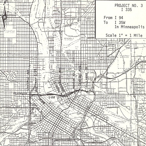 Map from 1975 of the plan for I-335
Interstate 335 was first proposed in the 1940’s to connect I-94, at Plymouth Avenue N, to I-35W, between East Hennepin Avenue and Broadway Street NE, which would complete a highway loop around Minneapolis. Since this “North Ring” section would go right through a big chunk of lower Northeast, it took a few decades for the Minnesota Department of Transportation to carefully choose the most fitting design for the area. In 1970, the project started to pick up steam when a federal highway bill granted money to the project to buy right-of-way land and prepare the route for construction. In fact, if you head southbound on I-35W, you can still see the beginnings of an on ramp as you approach the East Hennepin Avenue overpass.
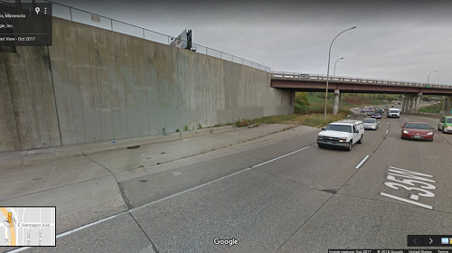 Google Maps picture of I-35W near the East Hennepin Ave overpass showing an unused on-ramp
I-335 was planned to start at Plymouth Avenue N with its first on/off ramps at Washington Avenue N. It crossed the Mississippi River just south of the Plymouth Avenue bridge, curved its way through Boom Island and B.F. Nelson parks, and its first on/off ramps on the Northeast side would have been at Main Street, where Marshall Street breaks off, roughly where the Pioneer monument currently stands. I-335 would have then continued east, with on/off ramps at University Avenue NE and 4th Street NE. Its last on/off ramp before it that would have connected to I-35W was planned to be at Monroe Street NE.
It’s hard to comprehend a six-lane highway going right through my favorite riverfront park, but it was very close to happening. Understandably, the residents of the St. Anthony West neighborhood were not happy about a highway going through their backyard. Led by their president, Patrick Rainville, Sr., the grandfather of yours truly, the St. Anthony West neighborhood board fought tooth and nail to stop this project. This was a daunting task, as no neighborhood organization has ever shut down a federal government project. Well do I have good news for you! History was made on July 25, 1975 when the Minneapolis City Council listened to one of their oldest neighborhoods and passed a resolution opposing the I-335 project.
When the weather warms up and you find yourself at Boom Island Park, take a moment to look at the Minneapolis skyline, smell the wildflowers in the fields, wave hello to the canoers and kayakers, and appreciate the natural beauty of the Minneapolis riverfront.
- - - - - - - - - - - - - - - - - - - - - - - - - - - - - - - - - - - - - - -
 About Michael Rainville, Jr.
A 6th generation Minneapolitan, Michael Rainville, Jr. received his B.A. in History, Graduate Certificate in Museum Studies, and M.A. in Art History from the University of St. Thomas.
